Canadian Rail Excursion
Overview
We had set out from the far away flatlands and alligator filled swamps of Southwest Florida. Covid-19 had delayed the trip for three years. After a few nights at the comfortable and fashionable Fairmount Vancouver Hotel, a very well-informed guide named Jeff took us on a six-hour odyssey of greater Vancouver. We visited parklands, monuments and all manner of cultural sites, to get a flavor of a very attractive and prosperous city. Homes here run into the millions, mere condos start out at $400,000. The central part of the city is composed literally of sparkling towers of glass condos, stacked dozens of stories into the Pacific sky. The Lion's Gate Bridge frames the busy commercial bay. Float planes landed and took off, as harbor ferries carried passengers to nearby Victoria on Vancouver Island. Huge passenger liners docked at the enormous Canada Place Pier, topped by five enormous white sails. It was a pleasure just to visit and watch all of the activity that takes place there every day. After enjoying the densely packed urban beauty of Vancouver, we were ferried by rail, north and east, through the Jasper National Park, by the wonderful staff of the Rocky Mountaineer Rail Line.
For the initial run of the Rocky Mountaineer, we travelled through a “tunnel of trees,” mostly tall and slim Douglas Firs, espying the urban detritus of greater Vancouver. Cement plants, steel yards and junk piles were interlaced with all of the other necessities for the urban colossus. A constant array of Canadian Rail traffic passed us by, headed south to Vancouver. Maersk, CNN, One, Yao Ming, and a dozen other carriers that employ the sea-land express, were carrying all manner of goods back and forth. Some of the trains ran to over two hundred cars.
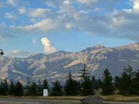
The Canadian Rockies are part of the “Grand Escalier” or grand stair case, that starts very far south in the Baha Peninsula of Mexico. Two enormous tectonic plates had collided along this line that runs thousands of miles from Mexico into the Arctic. The enormous collision forced the Pacific plate to subduct (go under) the Atlantic plate. The force of the process lifted an entire range of mountains some fifteen thousand feet into the air from their underground bed far beneath a primordial sea. The central peaks of this mountainous spine is called the “Continental Divide.” All water running down the western half flows into the Pacific or Arctic Ocean. Everything to the east makes its way to the Hudson Bay, Atlantic Ocean or Gulf of Mexico. Curiously, the Canadian or Pacific plate has granite bases, with dolomite, quartzite and other softer sedimentary stones at their summits, while the eastern plate was topped with granite and has the softer sedimentary stones at their base. Both ranges are impossibly old and being worn down daily by wind, water and ice.
The eroded peaks were carved initially by the seas and later by the winds, into eroded castles and heroic figures stretched along the skyline. The icy “freeze and thaw process,” that all northerners are familiar with, is literally the “chisel of God” that carved out all manner of shapes and images from their sedimentary stone faces. Looking into these mountains is like cloud watching. You can see anything your imagination wishes in their fantastic shapes and varied hues. The primitive First Nation peoples had attached all manner of symbolism and mystical importance to these towering mountains for thousands of years.
Later, when the fur traders, of the Hudson Bay Company and early railroad pioneers first ventured into the area, they renamed the peaks, shifting from the colorful First Nation names, to commemorate early explorers and people important to the traders and railroad men. One commemorated a British Peer, Lord Fitzwilliam. Others memorialized important females who had helped the early traders. One mountain got named after an especially good cook on an expedition. To try and name the many hundreds of peaks that we saw, without a map, is a fool's errand. Many of the early traders and railroad officials were of Scot's origin. Their names now emblazon many forest area lakes and mountains. But, First Nation names still crown many glaciers and rivers, like the Athabasca Glacier and River.
It was the coming of the railroad, in the late 1800's, that changed the area forever. Financed by the Bank of Montreal, the Canadian National Railway would lay down pathways of iron that would facilitate the arrival of many thousands to the area. As an incentive, the railroads were given 33 square kilometers, by the Canadian government, for every kilometer of rail laid. The land was then sold to developers and settlers to help finance the cost of building the railroad.
It was the creation of National Parks, like Jasper and Banff, that defined and saved the region. Strict rules for development and preservation survive today in a national effort to preserve and protect these wilderness areas for future generations. In towns like Jasper and Banff, there is a “right to live” rule that requires an owner, to either work in those towns or own companies in them, in order to qualify for residency. They also have three-and one-half story height limits for any new construction so that the mountain views will never be obstructed.
As our train proceeded northward, the flora around us changed, from heavily forested and pine scented Douglas fir trees, to a semi-arid dessert around Kamloops and Jasper. We enjoyed viewing higher and higher eroded formations of the Canadian Rockies. Layers upon layers of sedimentary rock, visible to the eye, attested to the provenance of these high peaks, and their start eons ago, as under water reefs in a primordial ocean.
An electrical outage, in the town of Kamloops, kept us in the dark at the Best Western. Unphased, our colleagues hoofed it to a nearby plaza for essentials and patiently waited until the electrical crews repaired the blown transformer. It is what you do when traveling. When you run into an obstacle, you make do and continue to rock and roll. The next morning, the Rocky Mountaineer ferried us north and east through the semi-arid mountains to the small and attractive town of Jasper. After settling in, we hoofed it into town for spirits and provisions. Although we missed them, other guests in our hotel had witnessed a large female elk, and four of her young calves, walk through the grass around the hotel. Nearby, in a residential area, a mama bear and her cubs had to be shooed out of town by police, before residents could return to their homes. We truly were in the wild and this was the animal's home.
Not far north of the city, we trained slowly by a stone memorial to the two dozen WW I Canadian soldiers who had been killed here in a head on train crash. A newly hired telegraph operator had inadvertently sent the wrong signals to the two trains who hit each other head on. The telegraph operator was charged with capital offenses. The trial involved a future Premier of Canada, who led the defense. The mountains were beginning to rise around us as we sped away from Vancouver.
On Wednesday morning, a genial Irish-Canadian, named Martin ”Fireball” Flanagan, President of Canadian Rail.Ca, picked us up with a comfortable land cruiser, to explore the many parks, glaciers and dramatic water falls of both the Jasper and Banff National Parks. The Columbia Icefields, with a motorized trek in giant ice tractors, and a pedestrian walk out onto the Athabasca Glacier, were a particular favorite. Another dramatic skywalk gave the more adventurous a look through an arch, with a glass floor that extended some 115 feet outward from the cliff's edge, over the Athabasca River some 900 feet below. It had been built by the Brewster Company, who had erected a similar arch, cantilevered over the edge of the Grand Canyon. Surrounded by towering, dark and eroded peaks, and five separate glaciers, we thought ourselves fortunate to experience such a magnificent natural phenomenon that was fast melting away with the continued warming of the earth. We visited a series of glacially fed lakes, all resplendent with a sparkling iridescent jade, stained by the rock flour of melting glaciers. It brought forth the predictable “ooohs" and "ahhs" with the clicks of many cameras, trying to capture forever the beauty around us.
The pleasure of the Texas-like, cowboy town of Jasper and the beauty of semi-urban Banff, made for a wonderful introduction to a region of Canada not well known by those outside the area. Martin Flanagan's narration of the historical, cultural and geological provenance, of that which we were seeing, gave us an understanding of the many environmental and ecological concerns that we now face. Martin did his job with a smile and a patience not much known, this side of the abode of the angels.
In the ensuing narrative, I hope to spell out the daily adventures of our journey and the many interesting cultural, geographical and geological entities that captivated and entertained us for the length of our odyssey. I hope you enjoy the trip as much as we did.
Fri. August 19th, 2022- Amherst, N.Y.
We drove across the Canadian border, at the Lewiston/ Queenstown/Bridge. The auto traffic was light, so we sailed across with no complications. Traffic north on the Queen Elizabeth Expressway is always a challenge. After passing over the Burlington Skyway, we merged into a sea of metal all headed for Toronto. Sometimes the scrum slowed to 15 MPH, in a slinky like column. It was the opening weekend of the Canadian National Exhibition in Toronto. That, and the usual throng of weekenders enjoying the many pleasures of Toronto, created a monumental traffic snarl. Like most big cities, it is not so much about knowing the right directions, but being in the correct lane of traffic, to exit onto the right ramps. We ended up on the Gardiner Expressway, inbound for downtown Toronto. OOPS! We retraced our steps and managed to find the #403 and the correct exit for Dixon Road. The area is a conglomeration of six or seven major hotels and adjacent to Pearson Airport. We found and entered into the Marriott Hotel, where we would spend the night. They featured a better rate for parking, along with rooms going and coming to Vancouver. The Park & Fly lot charges $25 a day for parking. The hotel also has a shuttle for arriving and departing passengers. An early dinner set us up for an early retirement. We had to be at the airport by 7:30 A.M. the next morning.
Saturday, August 20th, 2022- Toronto, Canada.
We were up by 4:00 A.M. packed up our gear and shuttled over to terminal three of Pearson Airport. We were flying on West Jet to Vancouver. The 10:30 A.M flight would take a brief five hours to deposit us in Vancouver. Even at this early hour, the airport was jammed with throngs of travelers. The line for Tim Horton's coffee had to be 150 people long. Like most Canadians, we too were devotees of this magical brew.
It was an uneventful five-hour ride into Vancouver airport. I was reading another John Sanford mystery. It kept me occupied for the ride. At Vancouver, we deplaned and collected our bags with no trouble. A convenient taxi ferried us across town to the venerable Fairmont Hotel Vancouver. It was one of those elegant Canadian Pacific Railway hotels that are so distinctive in appearance. They lie along the railway, all across Canada.
The room wasn't yet ready, so we parked our bags with the Concierge and walked around the area. It is one of the “ne plus ultra” areas of downtown Vancouver. Shops, like Gucci, Dior, DeBeer Diamonds, Rolex and a dozen other wallet busters lay all around us on Alberti and West Georgia Streets. The Vancouver Art Museum sits right next door. We noticed a liquor store and stopped by to pick up a bottle of Josh Cabernet and some Smirnoff's medicine for the room. An auto immune affliction had reduced my ability to walk far, so we drifted back towards the hotel. We passed by an interesting market, “Urban Fare,” that sold fresh produce and also featured a cafeteria with salads, pizza and all manner of sandwiches. We sat down to Falafel sandwiches, something new for us. They are a middle eastern delight that incorporates mashed chick peas and vegetables. They are a new favorite for us. By now, the hotel had texted us and advised that the room was ready. We walked back over Alberti St. and picked up our room keys. (#553) The concierge bellman soon arrived with our bags. We tipped him liberally and settled in to begin our Canadian adventure. The Fed-Ex golf tourney was on television and kept us entertained until the sandman claimed us.
Sunday, August 21, 20220 Vancouver, Canada
We were up at 3:30 A.M. a victim of circadian rhythms. I have been this way many times, visiting family in Southern California. I knew that it would probably take us three days before our bodies adjusted to the local time format. Coffee and muffins in the room got us going.
Three blocks over Burrard Street, near the Sutton Place Hotel, is a stop for the “hop on hop off bus” tour of Vancouver. It is a ninety-minute passthrough, that allows you to get off at any stop and get back on later. For $59 each, it was a nice way to the see the city. We had been here twice before on different tours, but every time you come back to a city, you see new things.
The first thing we became aware of was the many stacks of blue, mirrored glass that make up the condos in downtown Vancouver. There is a virtual forest of them, all tall and sparkling in the morning sun. One novelty tower was a stack of condos that were all set off-center from each floor level. Wags had named it the “Rubik's cube.” The guide said that planners had lured some 100,000 young people back to the city center with these condos. Curiously, many of these units had been constructed without air conditioning.
Amidst all great cities, there is the tragedy of the homeless. We passed through the intersection of Penders and Main Streets, viewing the small army of tents erected on the city streets there. Hundreds of the unfortunates made their homes there in makeshift tents.
Passing over the Granville Bridge, we could see the public markets below us. This is a favorite stop of many Vancouverites. We would stop by there tomorrow for lunch. Out into the English Bay, we could see cargo ships and cruise liners, with the Tantalus mountains as a backdrop. We traversed China Town and heard its storied history. Then, “Gastown,” where we watched the performance of the fabled Steam Clock, tooting once each hour to mark the time.
The last stop for us was “Canada Place.” The main feature, of these elegant cruise ship docks, is the Pan Pacifica hotel. We had stayed there on another trip. From its Olympian heights, you can view the Lion's gate Bridge in the distance. Float planes landed and took off all day, from their harbor dock nearby. The sleek harbor ferries, at the terminal next to us, chauffeured passengers to nearby Victoria on Vancouver Island. When we arrived, the place was a swarm, with crowds of people. Two cruise ships, from the Celebrity and Holland America lines, were unloading their passengers from Alaskan Cruises. Piles of new passengers sat around the square, hoping for an early boarding on the outbound ships. We found a Starbucks and sat down for some of that delicious brew and a croissant. A constant stream of day trippers was arriving. We discovered later that nearby was the waterfront terminus of the Vancouver subway. Throngs of visitors come here every day to hang out, have lunch and enjoy the waterfront. Stanley Park sits just across the harbor. Its 1,000-acre expanse features bike paths, hiking trails and other amenities like the “Tea House.” It drew in visitors like bees to honey. We would visit it tomorrow.
The sunny afternoon was waning. We walked up Burrard and stopped at an oddity named “Tractor.” It is a vegan restaurant that only accepted plastic. We enjoyed some wonderful butternut squash soup and bread there. Then, we made it back to the room for a recharge. The walk up the hill was a series of “bench to bench” stops for me.
The sun was still high in the late afternoon. We had decided on Joe Forte's for dinner. We had been there on a previous trip and much enjoyed their food. We thought we would be proactive and arrived at the restaurant by 4:15 P.M. All three levels of the huge place were chock ablock full. We managed to score a table on the third-floor terrace. A decent cabernet led us into a salad course and then a wonderful concoction called “Seafood Cioppino.” It is a fish stew, loaded with mussels, clams, shrimp and fish in a red sauce, that was magnificent. It was also light on the calories. To make up for this discipline, we selected key lime pie to finish off the repast. It was wonderful. And although pricey, Joe Forte's is worth the cost.
Walking back to the hotel, the temperatures were balmy. We enjoyed the early evening before returning to the room to fall into the arms of Morpheus. Tomorrow would be the official kick off of our Canadian excursion and we wanted to be fresh and ready for the tour.
Monday, August 22, 2022- Vancouver, Canada
We were up early at 3 A.M. victims of Circadian Rhythms. We settled into the lobby “Notch” dining room, at 7:30 A.M. for omelets and lox. Members of our tour group wandered in and we greeted each in turn. It was the beginning of our Canadian Rockies Excursion.
Jeff, our guide for the day, showed up at 9 A.M and scooped us up for the day's tour. He proved to be a veritable font of information on Vancouver. The City was named after Captain George Vancouver, who had first explored and mapped the area for the British in the 1790's. He had been a midshipman on Captain James Cook's early voyage exploring the area. The city has over 2.5 million residents, in 23 neighborhoods, scattered across 44 square miles. It has over 200 public parks and a vibrant downtown area, composed of thousands of condos that we had seen yesterday in “The Glass City.”
Jason, our capable driver, piloted us down the road, stopping at the eight story Vancouver Public Library. The building is circular in form and looks like a modern version of the Roman Colosseum. We trooped up to the roof top terrace where Jeff pointed out the various sports stadia and other prominent features. An unexpected bout of Vertigo had me beat a hasty retreat from the terrace. We then found our bus and passed over the Bay Bridge enjoying the English Bay and Tantalus Mountains scape.
Our next stop was Queen Elizabeth Park. It is named after the mother of the current Queen. Laced with bike and hiking paths, the series of hills and elevated viewpoints features beautiful sunken gardens, a crystal dome and a circular water fountain that started the camera's clicking. Along the way, we noticed oddities like the “Monkey Tail Puzzle Tree,” a “weeping Peach Tree” and other colorful botanical specimens. At a higher viewpoint we all enjoyed the bronze sculpture “photo session.” One of the trio of subjects playfully patting the butt of the photographer's wife. From here, we could look far off into the skyline looking at the Tantalus Mountains. Jeff pointed out to us a raised portion of the range. Up close, both small promontories there gave the appearance of sleeping lions. It is from these, twin, stone felines that the “Lion's gate Bridge” and several local sports teams draw their name.
We proceeded on next through the ”Shaughnessy section” of elegant homes. Built in the 1910 era, for rail road executives, these two-story mansions had cost the princely sum of $6,000 at the time. Now, they would sell for millions, if you could ever get the chance to buy one. It was a portrait of grace and structural elegance if a very crowded city.
Passing through China Town, Jeff explained the provenance of much of the area's Asian population. They had literally been imported into the area to help construct the rail roads in the late 1800's. When completed, many stayed on and sent for their families. An attractive arched gate, with Chinese characters, was the entrance to the area. A Chinese Cultural center features a Zen-like “Sun Yat Sen” garden and other representations of their far away homeland.
On the way to Gastown, we passed through the Penders and Main St section, with their unfortunate homeless population stirring from the array of tents on the sidewalk.
In the Gas Town section, we pulled over to watch the noon performance of the famed steam clock. Promptly at twelve, the steam clock tooted a medley and then twelve toots to note the hours. The real cache' of the area comes from a nineteenth century bartender and saloon owner named John Deighton. He apparently had been a tale-teller and “gasbag” of the first magnitude. The locals called him “gassy Jack” for this trait and repeated bouts of flatulence. His Hotel Deighton had burned down and been rebuilt in 24 hours with the promise of whiskey for the carpenters and saw mill owners. They must have had Irish workmen. Now, gift shops, restaurants and coffee shops crowd the area.
Around the corner, we entered and admired an old railway station. Outside, a poignant statue, of the winged goddess Victory, held the supine form of a fallen Canadian soldier. It is a tribute to all of the many Canadian men and women who had fought and fallen in WWI & II.
The bus picked us up and we drove by Canada Place. As usual, the area was swarming with visitors, cruise ships, float planes and harbor ferries carrying passengers hither and yon. Traffic was snarled across the surrounding streets.
From Canada Place, we drove across the Granville Bridge and entered one of the more popular attractions in the area, the Granville Public market. Some fifty thousand square feet of space holds vendors of every imaginable food stuff, notion and gifts. Surrounding the market are artistic studios and craft shops. The Market itself was awash in visitors. It was lunch time and guests, who either drove or took one of the harbor ferries, over from Canada place, crowded the market.
We wandered amidst the booths, admiring all of the produce and products on sale. We were headed for a particular booth where we had great clam chowder on a previous visit. There, we ordered pint cartons of a wonderful lobster bisque. Together with some really tasty chocolate biscotti, they made for a great lunch, as we sat outside in the sun, admiring the waterfront around us and people from everywhere.
Jeff picked us up at 1:00 P.M. near the old Granville Hotel. Jason carefully piloted us through the traffic swarm and back across the Granville Bridge to drive along the waterfront area of English Bay. The Beach here and the grassy parkland are an idyllic setting. We were on our way to the most popular venue in the area, Stanley Park. The 1,000-acre expanse, named after Lord Stanley (same as the cup) was a series of walking and hiking paths along the bay. A large aquarium and many play areas entertained the City's families. Our stop was the “Totem Grove.” There, a series of nine, 30-foot totem poles feature the most interesting of the native crafts. Each Totem, usually composed of four separate sections, told a story in painted detail, featuring elaborate carvings of birds and animals from the region. We had viewed many such totems in Alaska and heard several interesting stories that each one features. We took many pictures and enjoyed this beautiful day on Vancouver's waterfront. The day was waning and the aging cargo of the bus as well. Jason piloted us through the heavy traffic of the city to our hotel. We Thanked and tipped him and Jeff, as we exited the bus.
Several of our colleagues went to the “Coastal Restaurant” for dinner. We were tired and elected to pick up two wonderful Caesar salads and five grained bread from the “Urban Fare” nearby. Together with a good cabernet, they made for a delicious repast as we watched the play during the last holes of the Fed ex cup. Rory McElroy had come from behind in an exciting finish, to win a small fortune by a single stroke. It had been a good day and a nice return to Vancouver. But, we were ready to move on. We started packing our gear and got ready for our rail travel on the morrow.
Tuesday, August 23, 2022 Vancouver Canada
We were in the hotel lobby with our bags by 7:00 A.M. Another larger group of tourists was also gathering, so it was a bit confusing at first. We soon hooked up with other members of our group and arranged our bags for pick up by staff of the Rocky Mountaineer line. A bus delivered us to the nearby rail station. Efficient staff there sorted us out and directed us to our rail cars. Several of us were assigned the Jasper # 6 car. We boarded, settled in and got ready to head out. Outside, a bag piper was playing energetically and the rail staff were waving us off. It had a holiday feeling.
Dyllan, our chief steward settled us all in and we left the station just after 8 A.M. Immediately, coffee, Danish and fruit were served to us. Then, our breakfast selection was delivered. It was to be two days of a caloric overload that kept us contented and occupied. The topper was the drink cart that rolled out at 10:30 A.M for whatever you fancied in spirits. We were travelling up the Frazier River Valley and on into the forest primeval that surrounds Vancouver.
For the initial run of the Rocky Mountaineer, we travelled through a “tunnel of trees,” mostly tall and slim Douglas firs, espying the urban detritus of greater Vancouver. Cement plants, steel yards and junk piles were interlaced with all of the other necessities for the urban colossus. A constant array of Canadian Rail traffic passed us by, headed south to Vancouver. Maersk, CNN, One, Yao Ming, and a dozen other carriers that employ the sea-land express, were carrying all manner of goods back and forth. Some of the trains ran to over two hundred cars.
The train slowed as we passed the “hell's gate” river formation. It is a narrow gorge, of the Frazier River, that channels water at great speed through a narrow gap of rocks. Dyllan told us that only a few weeks before the Frazier River had risen some 30 feet and the rapids effect was dramatic and deadly.
Lunch time continued the caloric onslaught. Salads, an entrée and a lemon tort filled up the waiting guests, as we watched the “tunnel of trees” flow by us. The tall Douglas Firs have a fire-resistant bark that makes them survivors of the frequent forest fires across the years.
As our train proceeded northward, the flora around us changed, from heavily forested and pine scented Douglas fir trees, to a semi-arid dessert as we approached Kamloops and Jasper. We enjoyed viewing higher and higher eroded formations of the Canadian Rockies. Layers upon layers of sedimentary rock, visible to the eye, attested to the provenance of these high peaks, and their start eons ago, as under water reefs in a primordial ocean.
We passed through the Thompson Canyon area. Dyllan pointed out the Highland Copper mining complex. It provides nearly four per cent of the world's copper. At Rainbow Canton, we could view the dark rocks, colored by minerals beneath them, stenciled across the semicircular rock face. Like most of what we were to see in the next few days, the visual effects of the rocks around us held us in awe. Crossing Spenser's Bridge, we heard tales of a duel between a cook and a settler when the area was first settled. Meba Canyon featured a sheet of dark moss covering the cliffs around us. The desert area was getting dryer. The small town of Ashcroft flashed by. Its two thousand residents, many of whom worked for Highland Copper, received but 12 inches of rain yearly. The soils around them were parched.
We were approaching the Town of Kamloops, B.C. The term was native for “meeting of the waters.” The North Thompson and the South Thompson rivers met and merged here, creating the bigger Thompson River. The substantial town featured three world class golf courses and a small commercial strip.
It was late afternoon, when we arrived at our Best Western Hotel. Unfortunately, a bus had backed into and destroyed an electrical transformer at a nearby hotel, shutting off power to the area, our hotel included. Undeterred, several of us walked to a nearby plaza for provisions. Most of the stores there were out as well. The one restaurant open had a line out the door. When you travel, you meet obstacles like this with a philosophical shrug and rock on. The power soon returned and we settled in for the night, with spirits to guide us into Morpheus's arms.
Wikipedia entry for Kamloops:
The first European explorers arrived in 1811. o "David Stuart (fur trader)" David Stuart, a trader sent from o "Fort Astoria" Fort Astoria, then still a o "Pacific Fur Company" Pacific Fur Company post, spent a winter with the o "Secwepemc" Secwépemc people. In May of the following year, trader .org/wiki/Alexander_Ross_(fur_trader)" o "Alexander Ross (fur trader)" Alexander Ross established a post, which was known as "Fort Cumcloups".
The rival o "North West Company" North West Company established Fort Shuswap nearby in the same year. The two businesses merged in 1813 when the North West Company bought the operations of the Pacific Fur Company. In 1821, the o "Hudson's Bay Company" Hudson's Bay Company took over the North West Company, and the post became known commonly as Thompson's River Post, or Fort Thompson. Later it was known as Fort Kamloops.l "cite_note-bcgnis-7" [7] The post's Chief Traders kept journals, which document a series of inter-Indian wars and personalities for the period, in addition to the daily business of the fur companies and their personnel along the entire o "Pacific Slope" Pacific Slope.
Soon after the forts were founded, Kwa'lila, chief of the main local village of the Secwépemc, moved his people closer to the o "Trading post" trading post, so they could control access and gain in prestige and security. After Kwa'lila died, his nephew and foster son o "Nicola (Okanagan leader)" Nicola became chief. He later led an alliance of o "Syilx" Syilx (Okanagan) and o "Nlaka'pamux" Nlaka'pamux peoples in the plateau country to the south around o "Stump Lake" Stump, o "Nicola Lake" Nicola and o "Douglas Lake" Douglas lakes.
Relations between Nicola and the o "Fur trade" fur traders were often tense, but Chief Nicola was recognized for his aid to whites during the o "Fraser Canyon Gold Rush" Fraser Canyon Gold Rush of 1858. He did try to control those who had been in parties waging violence and looting on the o "Okanagan Trail" Okanagan Trail, which led from American territory to the o "Fraser Canyon Gold Rush" Fraser goldfields.l "cite_note-8" [8]l "cite_note-9" [9] Throughout, Kamloops was an important way station on the route of the o "Hudson's Bay Brigade Trail" Hudson's Bay Brigade Trail, which connected Fort Astoria with o "Alexandria, British Columbia" Fort Alexandria and the other forts in o "New Caledonia (Canada)" New Caledonia to the north (today's o "Omineca Country" Omineca Country, roughly). It was integral during the onset of the o "Cariboo Gold Rush" Cariboo Gold Rush as the main route to the new goldfields around what was to become o "Barkerville, British Columbia" Barkerville.
The o "1862 Pacific Northwest smallpox epidemic" 1862 Pacific Northwest smallpox epidemic swept through the Kamloops area during the summer of that year, decimating the Secwepemc, Nlaka'pamux, and other indigenous peoples. They had no acquired immunity. The epidemic had started in o "Victoria, British Columbia" Victoria and quickly spread throughout British Columbia, especially among First Nations. In June 1862, indigenous people went to Fort Kamloops seeking o "Smallpox vaccine" smallpox vaccine, William Manson, chief clerk at the fort, vaccinated numerous persons, but fatalities were extremely high. In late September he reported "smallpox still raging amongst the Indians".
In October a newspaper in Victoria reported an eyewitness account from Fort Kamloops, saying
"The Indians have been nearly exterminated at [Kamloops]: only sixteen have escaped out of a large settlement. Their bodies are strewing the ground in all directions."
About two-thirds of the Secwepemc died during the epidemic. In the aftermath, colonists took over traditional lands of the Secwepemc and many other indigenous groups throughout British Columbia.l "cite_note-10" [10]l "cite_note-11" [11]l "cite_note-12" [12]l "cite_note-rijn-13" [13]
The gold rush of the 1860s and the construction of the o "Canadian Pacific Railway" Canadian Pacific Railway, which reached Kamloops from the West in 1885,l "cite_note-14" [14] brought further growth. The City of Kamloops was incorporated in 1893 with a population of about 500.
The logging industry of the 1970s attracted many o "Indo-Canadian" Indo-Canadian workers to the Kamloops area. They had come mostly from the o "Punjab, India" Punjab region of o "India" India. In 1973, Kamloops annexed o "Barnhartvale" Barnhartvale and other nearby communities.
In May 2021, an anthropologist announced she had used o "Ground-penetrating radar" ground-penetrating radar to find "probable" graves containing the remains of 215 children found at o "Kamloops Indian Residential School" a former Kamloops Indian residential school, part of the o "Canadian Indian residential school system" Canadian Indian residential school system.l "cite_note-15" [15] The story was reported around the world, and five o "Catholic" Catholic churches in Western Canada were burned down in the weeks following since the school was operated by a Catholic order.l "cite_note-16" [16] However, this story cannot be completely confirmed until bodies are exhumed.l "cite_note-17" [17]l "cite_note-18" [18]l "cite_note-19" [19]
Wednesday August 24, 2022- Kamloops, British Columbia-Canada
We were again up at 3 A.M unable to alter our Circadian Rhythms. It was 64 degrees out. We packed up our bags, had some coffee and assembled in the hotel lobby at 7:10 A.M. The bus arrived, scooped us up and drove us to the rail yard. The driver must have mentioned the phrase “disembark from the motor coach” eleven times in our short run. When he said it the final time, we had to laugh.
Jasper car #6 welcomed us and we settled in for the day. Dyllan and his staff brought coffee and pastries as soon as we started to roll. It would be another gut-buster today. Salmon and eggs, with potatoes, soon followed. I was already saying “mooo.” The area around us was rich in farms and cattle ranches. Dyllan said they had some 250,000 head of cattle hereabouts. No wonder I thought it looked like Texas.
As we rattled northward, we could see evidence of the great “McClure Fire” of 2005. Seventy-five homes were lost in that blaze. Oddly enough, the fire had started when a volunteer firefighter tossed a lit cigarette carelessly into the grass. After that blaze, he wasn't too popular around town. Many of the burned trees were skeletal. A whole crop of younger conifers was already sprouting up around them. The gulleys and small hillsides were dusty-brown like the Texas Hill Country.
The further north we got, the countryside around us was shifting into the “Hemlock region.” Aspens, silver birch and creek willows started to replace the ever-present Douglas firs. At Vavenbee, we saw evidence of the Keystone Pipeline in progress. Whether or not it will ever get U.S. approval to cross the border is still up in the air.
Dyllan gave us a good talk on logging in the park. Park management awarded loggers diamond shape patterns of trees for logging in the woods. In this manner, whole watersheds of hills were not clear cut and the hillside washed out. Recovery chances were improved. The government also held yearly lotteries, featuring what types of wood could be logged that year, depending upon what foresters advised them. Usually most loggers make for the black walnut, cherry and oak trees as the most valuable. The lottery prevented this. Also, lastly, helicopters were employed to harvest hard to reach trees. It was a thoughtful approach to wood harvesting and forest management. He also started a tale of the “overlanders,” groups of trappers and explorers who had tried to reach the area by land, up from Calgary. Some made it, some didn't. The 1860's gold rush have fueled the mania.
Promptly at 12:00 lunch was served. Salad, fresh salmon with rice and another tort were all delicious. The wine was also flowing liberally. (mooooo). The train slowed to let us get a glance at “Pyramid Falls.” Twin streams of rushing white water cascaded down the mountain to crash in a local stream. We were climbing again and the Douglas firs returned. They appeared in the afternoon sun as soft and luxurious, emerald carpets of waving green, glistening in sunlight. Wave after wave of the conifers was mesmerizing.
Not far north Kamloops, we trained slowly by a stone memorial to the two dozen WW I Canadian soldiers who had been killed here in a head on train crash. A newly hired telegraph operator had inadvertently sent the wrong signals to the two trains who hit each other head on. The telegraph operator was charged with capital offenses. The trial involved a future Premier of Canada, who led the defense. The mountains were beginning to rise around us as we sped away from Kamloops.
Around one rocky bend, we saw an apparition. Mt. Robson, the highest mountain in Canada slowly came into view, standing over 13,000 ft, the towering rocky crag can be seen from many miles away. A few of the “camera hogs” from the front of the train were starting to get on our nerves with their jumping up and down at every opportunity and hogging the photo platform.
Dyllan's narrative continued with his explanation of the five-year cycle of salmon that abounded in the area. The five different types (Sockeye, Coho, Chinook, Pink and Atlantic) all spawned in the area. The tiny fish, when they hatch, swim down the Thompson River, and further down the Frazier river until they reached the Pacific Ocean and maturity. Like a mental alarm clock, they returned from thousands of miles away, to climb the rivers to spawn again in the place where they were born. At places like Hell's Gate, fish ladders had been erected to help the hearty fish climb over the rapids. Scientists theorize that a metal direction finder in their head led them homeward. They also think that the salmon can smell home from several hundred miles away. It is a remarkable journey. Everywhere along the way, Bears, bigger fish, sharks and other predators try to thin out the schools. The worst predator of course is us. (Pogo)
We passed Moose Lake, headwaters of the Frazier River. It had that murky jade coloration, laden with rock flour. We were approaching the Continental Divide. Mt. Fitzwilliam, named after a British Peer who had explored the area, loomed ahead. Yellow Head Lake has two tons of coloration, probably due to different glacier material. We also lost an hour, as we entered into the Mountain Standard Time.
The drink cart rolled by and we enjoyed a glass of cab/merlot in the late afternoon. Chocolate cookies also made an appearance.(moooo). At 6:00 (MST) we arrived in Jasper and were bused to our hotel, the Forest Park. The bar was SRO. We settled into the room and then went for a walk into town, about 900 yards in. A liquor store there provided us with additional spirits and some munchies from a small grocery store. The town appeared to be overrun with tourists like us. It was sultry and warm out, as we walked back to the hotel. We settled in, caught up with my notes and then drifted into the arms of Morpheus.
Guests who had sat outside later than we, saw a mature elk and four of her calves walk through the grass around the hotel. In town, a bear and her cubs had to be shooed out of a residential area so homeowners could return. This was their home.
Wikipedia entry for Jasper:
Established in 1813, o "Jasper House" Jasper House was first a o "Fur trade" fur trade outpost of the o "North West Company" North West Company, and later o "Hudson's Bay Company" Hudson's Bay Company, on the o "York Factory Express" York Factory Express trade route to what was then called "o "New Caledonia (Canada)" New Caledonia" (now o "British Columbia" British Columbia) and o "Fort Vancouver" Fort Vancouver on the lower o "Columbia River" Columbia River.l "cite_note-5" [5] Jasper House was 35 km north of today's town of Jasper.
o "Jasper Forest Park" Jasper Forest Park was established in 1907. The o "Railway siding" railway siding at the location of the future townsite was established by o "Grand Trunk Pacific Railway" Grand Trunk Pacific Railway in 1911 and originally named Fitzhugh after a Grand Trunk vice presidentl "cite_note-6" [6] (along the o "List of Grand Trunk Pacific Railway stations" Grand Trunk's "alphabet" line). The o "Canadian Northern Railway" Canadian Northern Railway began service to its Jasper Park station in 1912, about 700 m from GTP's Fitzhugh station.l "cite_note-lothian-7" [7]The townsite was surveyed in 1913 by H. Matheson.l "cite_note-lothian-7" [7] It was renamed Jasper after the former fur trade post. An o "Ukrainian Canadian internment" internment camp was set up at Dominion Park in Jasper from February 1916 to August 1916.l "cite_note-8" [8]
The park was renamed Jasper National Park in 1930. By 1931, Jasper was accessible by road from Edmonton. In 1940, the scenic o "Icefields Parkway" Icefields Parkway opened, connecting Jasper to o "Lake Louise, Alberta" Lake Louise and o "Banff, Alberta" Banff in o "Banff National Park" Banff National Park.
The first step towards incorporation of Jasper occurred on August 31, 1995 when the Jasper Improvement District was formed from a portion of o "Improvement District No. 12" Improvement District No. 12 (Jasper National Park).l "cite_note-AMAProfile1-9" [9] The o "List of improvement districts in Alberta" improvement district was subsequently incorporated as a specialized municipality under the name of the Municipality of Jasper on July 20, 2001.l "cite_note-AMAProfile1-9" [9] The incorporation order established the Jasper townsite as the Town of Jasperl "cite_note-incorp-10" [10]and the surrounding balance of the specialized municipality as a rural service area that was deemed equivalent to a o "List of municipal districts in Alberta" municipal district.l "cite_note-JSCP-11" [11]
The Municipality of Jasper is in the western portion of the province of Alberta within Jasper National Park.l "cite_note-basemap-12" [12] It borders the province of o "British Columbia" British Columbia to the west and o "Improvement District No. 12" Improvement District No. 12 to the north, east, and south.l "cite_note-basemap-12" [12] The Athabasca River, which originates from the o "Columbia Icefield" Columbia Icefield, meanders northward through the municipality.l "cite_note-basemap-12" [12] The o "Miette River" Miette River, o "Maligne River" Maligne River, and o "Snaring River" Snaring River all discharge into the Athabasca River within the Municipality of Jasper's limits.l "cite_note-basemap-12" [12]
The Jasper townsite, which is approximately 362 kilometres (225 mi) west of o "Edmonton" Edmonton, 290 kilometres (180 mi) north of Banff, and 28 kilometres (17 mi) east of the o "Yellowhead Pass" Yellowhead Pass, is at the intersection of o "Alberta Highway 16" Highway 16(o "Yellowhead Highway" Yellowhead Highway) and o "Alberta Highway 93" Highway 93 (Icefields Parkway). It is near the confluence of the Athabasca River and Miette River. It lies between the o "Victoria Cross Ranges" Victoria Cross Ranges (northwest), o "Pyramid Mountain (Alberta)" Pyramid Mountain (north), o "Maligne Range" Maligne Range(southeast) and Trident Ridge (southwest). Lakes near the Jasper townsite include o "Pyramid Lake (Alberta)" Pyramid Lake, o "Patricia Lake (Alberta)" Patricia Lake, Lake Annette, Lake Edith, o "Lac Beauvert" Lac Beauvert, o "Maligne Lake" Maligne Lake, and o "Medicine Lake (Alberta)" Medicine Lake.
Thursday, August 25, 2022- Jasper, British Columbia, Canada
We were up by 5:30 A.M. We readied for the day and then had “poached eggs Athabasca” in the hotel restaurant, with John and Stoney Frame. Dining with and getting to know other members from Spring Run, was one of the many benefits of this excursion.
Martin Flanagan, President of Canada Rail Vacations, picked us all up at 9 A.M. in a land cruiser. This genial Irish-Canadian was to prove one of the more pleasant acquaintances that we made over the next four days. Educated at the University of Alberta, Martin was also a Canadian Olympic Luge member, long range cyclist and a veritable font of information on all matters regarding history, geology and ecology in the Canadian Rockies.
Next on our line of march was Maligne Canyon and Falls. It is a steep gorge of the Mailgne River that has eroded a crevice some 90 ft. deep, rushing white water, before flowing into the Maligne Lake. We walked about one kilometer along the river and across two wooden bridges, snapping pics along the way. The Maligne Falls are a fast-flowing, white water spurt of the river before it ends up in Maligne Lake, which we would visit down the road. We were also to find out that Martin's estimation of distances was a little short of what we experienced. Perhaps his excellent physical condition made walking much easier for him. The word “maligne” in French mans “bad.” Apparently, a French cleric had had an unpleasant experience with the falls and river. Rather than curse, his training would only allow him to say “bad,” rather than a much earthier epitaph. The good Abbe had also named the place “Sore-foot Lake” for the same reasons but that name faded over the years.
We were now in Banff National Park. It had been formed in 1907 by the Canadian government. Lush with Douglas firs, the preserve was also home to over 400 grizzly bears and 400 Black bears, as well as elk, deer moose and a bevy of smaller animals. Park wolves fed on all of the above. The caribou had once been plentiful here but over harvesting had banished their remaining species to the Artic.
In all of Canada's national parks, visitors are charged $10 per person per day. All of these revenues are returned to the parks for infrastructural improvements, ranger/warden salaries and other needed means to preserve and protect the parks. In Banff Park, some six million visitors per year add to these coffers, helping insure the park's protection and preservation.
The beavers, with their soft, bushy pelts had first drawn trappers here in the early 1800's. The Hudson Bay Company getting its start and becoming among the largest of the fur gatherers. Beaver felt hats were all the rage then in Europe and the demand for beaver pelts was enormous. The First Nation people were the original trappers and their early interactions with the white traders were uneven. Individual tribal loyalties often conflicted and caused the white traders no end of problems. But, these tough and hardy people carved out civilized towns, from a vast expanse of wilderness, whose beauty we were now enjoying.
During the bus ride, Martin spelled out the whole gestation and reproduction cycle of these remarkable park bears. Their gestation period was only four to six weeks. As the tiny cubs emerged, during the winter hibernation, they affixed themselves to their mother's teats and nurtured there until spring. The brood could consist of up to four bears. Nature, in its ferocity, as well as local predators, usually thinned out that brood to one or two cubs per bear. The little rascals stayed by Mama's side for up to two years, learning to forage for berries, feed on fish in the rivers and survive by themselves.
The national parks also have as an important priority, the protection of the various groups of animals. In recent years, the number of animals killed or injured, while trying to cross the busy Trans-Canada Highway, has been increasing.
Working with preservationists, the parks had developed two types of “pathways,” to help the animals make their way safely across the busy roads. In one instance, a tunnel-like pathway was carved out, under a busy section of the highway. In another, a raised bridge actually spanned the highway. The “protected animal crossing bridge” was lined with trees and dirt, so that the animals would think it natural to use them.
Critics were not amused by the cost, some one million plus dollars each. Some wags even asked if they were going to post signs saying “bear crossing here.” And then, they asked how the animals would be able to read the new signage?
The Parks Administration, in cooperation with the University of Montana, ran a nine-year study of the crossings, monitoring, by a number of methods, how many and what type of animals actually, utilized the crossings. The study revealed that, during the nine-year period of the study, some 80,000 park animals, of all types, had actually utilized the two types of crossings. It also much reducing the number of animals lost to accidental encounters with trucks and automobiles.
We didn't see any arrows along the road, pointing to the crossings and no one knows how the animals figured out that these routes were the safest means to cross a busy highway. But, they did. Nature and the animal population, as we often discover, finds a way to do things that enhances their survival. Without a Parks Administration to help them, they well might be severely reduced in numbers. I still think it would be a gas to erected signs saying “bear crossing,” with arrows pointing in the direction of the bridges. The number of comments, from tourists, and the “huh reaction” would be worth the effort.
Maligne Lake was a picture-perfect portrait of an Alpine or Adirondack village. A gift shop and cafeteria sat lake-side and offered a spectacular view of the iridescent jade-colored Lake. Martin led our detachment for a brief one-mile long walk along the lake. Walking restricted, Mary and I sat in the sun at the café, enjoying some great coffee and even better oatmeal cookies. We watched visitors manning kayaks and canoes, making their way up and down the lake, A small tour boat also ferried visitors across the glistening jade waters. The visual portrait was idyllic. Later, Kathy Bartl joined us, to sit in the shade at a wooden lake view seating. The weather was gorgeous and we thought ourselves fortunate to be here with each other.
It was now mid-afternoon as we reached one of the day's highlights. The sky train, climbing up the side of Mt. Whistler. For $58 each, and 20 passengers at a time, a continuous line of visitors made their way, in gondolas suspended from over-head wires, for the seven- and one-half minute ride to the summit. I counted three dozen gondolas. So, you can imagine how many people they ferry up there daily. The view, reported by all, was breath-taking. Mary and Debby Feldhaus climbed the last few hundred yards to the summit. They reported that they could “see forever” across the Canadian Rockies. Most of the rest of the gang had ice cream cones at the base café.
I passed on the aerial tram and went back to the hotel to write up my notes and relax. Chris Cunningham also decided to skip the ride.
Mary said some odd person had brought a bird in a cage with her too see the mountain top. I suppose it never occurred to her that the bird could probably fly up by itself to see the sights.
That evening, Fran had made dinner reservations for all of us at “Cassio's,” in town. We made a quick change, and faithful Martin ferried us to the restaurant. I had some wonderful Pasta Pescatore, with tasty Italian bread and a very good cabernet. We sat with the Busseys and the Feldhauses during dinner and much enjoyed their company. It was part of the bonding process, that we much enjoyed on these travels. You discover how interesting those around you are, rather than the two-dimensional and shallow knowledge that we have of most people. After dinner, we made a very slow walk, for the 500 yards
Friday, August 26, 2022, Jasper Alberta
Martin picked us up at 9 A.M. Today was to be a very full day of touring. Our first stop was lake Patricia. Martin advised that early in the morning, we might catch a very picturesque image of Pyramid Mountain on the lake's surface. He was not wrong. We pulled into Lake Patricia, named for the Princess of Connaught, a granddaughter of Queen Victoria. The remarkable double image of Pyramid Mountain was reflected in the water, a remarkable photo-graphic image worth capturing. We “disembarked the motor coach" and took our pictures. The water was of the iridescent jade variety. The air was redolent with the piney smell of Douglas firs. The mountain air was refreshing.
We were headed south along the Icefields Parkway for Banff, some 150 miles south of us. The major stop for us today would be the Columbia Ice Fields. It is a convergence of five glaciers, sliding down Mount Athabasca and surrounding mountains. Athabasca Glacier, sits with Andromeda and AA glacier, glistening in the morning sun. Although they looked formidable, a guide said that these fields of ice represented but 1% of what had lain here some two hundred years before. Global warming would destroy even this huge remnant, in the next fifty years. We pulled into the large Ice Fields Center. Throngs of visitors were already there. A quick stop for the loo and we met Martin for a ride on another bus. This one would ferry us a few miles upward, along the Athabasca River to a vantage point some 900 feet above the River. The Brewster Company had constructed a three-hundred-yard pathway along the top of the gorge. At its end, a spectacular horse shoe stretched some 115 feet out into the gorge. It has a glass floor that visitors could look down into. It was dizzying, to even the most sure-footed. The company had erected a similar arch along the rim of the Grand Canyon in Arizona.
Afterwards, Mary and I jumped on another bus for the ride back to the center. We had some great coffee and decent falafel sandwiches. The place was aswarm with visitors. We checked out the entire center. A ticket kiosk advertised that visits for all of the attractions cost $125 each.
The rest of the group formed up, at yet another bus. We were headed for a ride on an ice tractor and a walk on the Athabasca Glacier. Though it looked nearby, the glacier was about one mile distant. There, we formed up for seats on a rather remarkable ice tractor. The wheels on these rascals were over six feet in height and cost some $7,000 each. The vehicle itself, was constructed to order by Mercedes of Germany, at a cost of $1 million eight hundred thousand dollar each. It has six gears and is capable of traversing a 21-degree grade, with ease. We strapped into our seats, and slowly our young guide rolled the monster down a steep grade and climbed up and onto the glacier to a pre-designated park area. In all of the land surfaces around us, we viewed clear, running streamlets from the melting ice glacier.
The facility crews had used a road-grader, to roughen up the very smooth glacier ice, into a small square, where we could park and “disembark the motor coach.”
The much-anticipated walk onto the glacier was somewhat less than we expected. Even on the roughened ice, we could barely stand up. I almost took a header right off the bus. It was both breezy and chilly out on the glacier, but not unpleasant. It was an experience. Not too many people can say that they have walked out onto a glacier. Just off in the distance we could see a small line of cross-country skiers, no doubt led by an experienced guide. Their skis must have had grabbing cleats on them, for they looked fairly sure footed. We all wished we had brought golf shoes for the walk.
After a time, the guide rounded us up. He had given strict warnings as to the time on the glacier and said that “he didn't wait” for stragglers. Any delay would cause the next scheduled visitors less time on the ice. Thinking about either a long walk or a very dangerous slide down the glacier, all the passengers of our bus were on time. The ride back was slow, but we were impressed with this marvelous and very expensive machine. The guide also related a story about drinking water from the glaciers. Most of us think of it as pure as spring water. “Not so,” he warned. After accidentally drinking glacier-water, from a proffered canteen, he had experienced some five days of dysentery-like conditions. Apparently, minerals in the melting glacier are incompatible with our systems. It can act as a supreme purgative agent. The bus ferried us back to the Ice Field Center, where we dutifully made stops in the loo and walked over to join Martin on the bus.
We stopped for a visit at the Sunwaptha Resort, to buy gifts and use the facilities. Afterwards, the bus carried us over the Sunwaptha Pass. It is the top of the Continental Divide and the border between Jasper and Banff National Parks. Mt. Saskatchewan stands high above the Saskatchewan River here. The river would flow far south into the province of that name. Mt. Murchison and the other eroded peaks around us formed the “Castleate Range.” They are dark of mien and Tolkienesque in appearance. You could well observe the effects of “God's chisel” in the eroded appearance of the mountains. Some looked like castles, others, the fortified walls of medieval towns. The erosion had streaked the rock face, giving them the appearance of man-made columns on these castles in the sky.
As we descended in altitude, we stopped at picturesque “Bow Lake.” The lake and moderate Bow Falls were another of those great picture backdrops, that we had all come to enjoy. “Marilyn Monroe and Lassie had “gone over the falls” in two old film epics. ”Peyto Lake” was another great stop. A steep walk, down to the lake, was rewarded with yet another iridescent jade beauty. There were so many similar buses in the lot, that it confused some of our passengers. After a bit, we were all rounded up and continued on towards Banff.
It was late afternoon, as we pulled into the delightful town of Banff, Alberta. Though comprised of only several thousand residents, it features a thriving pedestrian mall, lined with gift shops, restaurants, bars and other tourist attractions. We would walk the mall tomorrow.
We were staying at perhaps one of the most impressive, and certainly most expensive, hotels in all of Canada. The Fairmont Banff Springs is a stone-faced, multi-tiered medieval castle in appearance. It sits upon a hill, overlooking the village and surrounded by a mountain scape that would do well to an Audubon painting. An 18-hole golf course, riding and hiking paths made it an end destination. The inside was even more elegant. A hotel staffer met us on our bus and handed out room keys and information pamphlets. Our luggage was immediately carted up to our room by hotel staff.
It was now, 7:30 P.M. Rosemary Renda had arranged dinner reservations, at the Bear Street Tavern, a restaurant in town. We all made a brief visit to our rooms and then reassembled on the bus. Martin had graciously agreed to stay on late and ferry us into town. This noble Canadian did just about everything for us in these last four days. It was much appreciated by all. Martin told us that afterwards, it would be only a 700-yards walk back to the hotel.
The Bear Street Tavern, on the Pedestrian Mall, proved to be a delight. Friday night had drawn diners out in droves. In that it was more of a pizza and beer place, we had our initial doubts. But after a glass of very good Pinot Noir and an extremely tasty “Mediterranean Pizza,” we were happy that we had come. Mary and I sat with the Bartls and Cunninghams and exchanged pleasant dinner conversation. We were still learning about each other and much enjoying the process. Outside, a veritable torrent of rain had cleared the streets. We were never aware of it.
We and the Cunninghams shared a cab, Paula and the Bartls shared another one. For $15, we got a comfortable ride back to the hotel. More adventurous (and younger) companions had stayed on for revelry on a Friday night. Bless them for their spirit and stamina.
Wikipedia's description of Banff:
Banff is a town within o "Banff National Park" Banff National Park in o "Alberta" Alberta, Canada. It is located in o "Alberta's Rockies" Alberta's Rockies along the o "Trans-Canada Highway" Trans-Canada Highway, approximately 126 km (78 mi) west of o "Calgary" Calgary and 58 km (36 mi) east of o "Lake Louise, Alberta" Lake Louise. At 1,400 to 1,630 m (4,590 to 5,350 ft) above o "Sea level" sea level,l "cite_note-elevation-4" [4] Banff is the community with the second highest o "Elevation" elevation in Alberta, after Lake Louise.
The Town of Banff was the first municipality to incorporate within a Canadian national park. The town is a member of the o "Calgary Metropolitan Region" Calgary Regional Partnership.
Banff is a o "Resort town" resort town and one of Canada's most popular o "Tourist destination" tourist destinations. Known for its mountainous surroundings and o "Banff Upper Hot Springs" hot springs, it is a destination for outdoor sports and features extensive o "Hiking" hiking, o "Mountain biking" biking, o "Scrambling" scrambling and o "Skiing" skiing destinations within the area. o "Sunshine Village" Sunshine Village, o "Mt Norquay" Ski Norquay and o "Lake Louise Ski Resort" Lake Louise Ski Resort are the three nearby o "Ski resort" ski resorts located within the national park.
Toponymy[o "Edit section: Toponymy" edit]
The area was named Banff in 1884 by o "George Stephen, 1st Baron Mount Stephen" George Stephen, president of the Canadian Pacific Railway, recalling his birthplace near o "Banff, Aberdeenshire" Banff, o "Scotland" Scotland. The Canadian Pacific built a series of grand hotels along the o "Rail transport" rail line and advertised the o "Banff Springs Hotel" Banff Springs Hotel as an international tourist resort.
History[o "Edit section: History" edit]
Banff was first settled in the 1880s, after the transcontinental railway was built through the Bow Valley. In 1883, three o "Canadian Pacific Railway" Canadian Pacific Railway workers stumbled upon a series of natural hot springs on the side of o "Sulphur Mountain (Alberta)" Sulphur Mountain. In 1885, Canada established a federal reserve of 26 km2 (10 sq mi) around the o "Cave and Basin National Historic Site" Cave and Basin hot springs, and began promoting the area as an international resort and spa as a way to support the new railway.l "cite_note-6" [6] In 1887, the reserve area was increased to 673 km2 (260 sq mi) and named "Rocky Mountain Park". This was the beginning of Canada's National Park system.
The Banff townsite was developed near the railway station as a service centre for tourists visiting the park. Services, such as o "St George-in-the-Pines" St George-in-the-Pines, were constructed through the late 19th century. It was administered by the Government of Canada's national parks system until 1990 when the Town of Banff became the only o "Municipal government in Canada" incorporated municipality within a Canadian national park.
An o "Castle Mountain Internment Camp" internment camp was set up at Banff and o "Castle Mountain Internment Camp" Castle Mountain in Dominion Park from July 1915 to July 1917 mostly imprisoning Ukrainian immigrants.l "cite_note-7" [7] The prisoners of the internment camp were used as slave labor to build the infrastructure of the national park.l "cite_note-8" [8]
In 1985, o "United Nations" the United Nations declared o "Banff National Park" Banff National Park, as one of the o "Canadian Rocky Mountain Parks" Canadian Rocky Mountain Parks, a o "World Heritage Site" World Heritage Site. Banff remains one of the most popular tourist destinations in Canada.
One of the most notable figures of Banff was o "Norman Luxton" Norman Luxton, who was known as "Mr. Banff". He published the o "Media in Banff, Alberta" Crag and Canyon newspaper, built the King Edward Hotel and the Lux Theatre, and founded the Sign of the Goat Curio Shop, which led to the development of the Luxton Museum of Plains Indians, now the Buffalo Nations Museum.l "cite_note-BNLM-9" [9] He and his family helped organize the Banff Indian Days and the Banff Winter Carnival.
In 1976, the o "International Astronomical Union" International Astronomical Union's Working Group for Planetary System Nomenclature (IAU/WGPSN) officially adopted the name Banff for a crater on Mars, after the town in Alberta. The crater is at latitude 17.7° north and longitude 30.8° west. Its diameter is 5 km (3.1 mi).l "cite_note-10" [10]
In 1991, Banff hosted the o "1991 Winter Deaflympics (page does not exist)" 1991 Winter Deaflympics, the first o "Deaflympics" Deaflympics hosted in o "Canada" Canada, and the only Deaflympics held in Canada since then.
In response to the o "COVID-19 pandemic" COVID-19 pandemic, the town chose to temporarily close portions of its main street to vehicle traffic to create a o "Pedestrian zone" Downtown Pedestrian Zone.l "cite_note-11" [11] The Banff Town Council said the pedestrian zone will stay in effect until at least 2023.l "cite_note-12" [12]l "cite_note-13" [13]
Geography[o "Edit section: Geography" edit]
It is surrounded by mountains, notably o "Mount Rundle" Mount Rundle, o "Sulphur Mountain (Alberta)" Sulphur Mountain, o "Mount Norquay" Mount Norquay, and o "Cascade Mountain (Alberta)" Cascade Mountain. The town is above o "Bow Falls" Bow Falls near the confluence of the o "Bow River" Bow River and o "Spray River" Spray River. Soils are calcareous and usually imperfectly to poorly drained in their natural state with textures from very fine sandy loam to silty clay loam.l "cite_note-14" [14]
Saturday, August 26, 2022- Banff, Alberta, Canada
We were up by 6:30 A.M. It was cool and rainy out this morning. Breakfast, in the Vermillion Room, was excellent. Omelets, lox and fruit, with good coffee was a pleasant repast.
Martin picked us up at 9 A.M. We would be exploring Banff National Park today. Founded in 1885, as Canada's first national park, the area encompasses over 6,700 square kilometers. White spruce, poplar and lodge pole pines predominate the area, with the ever-present Douglas firs.
Emerald Lake was our first stop. It is another jade colored beauty. Even in the rain, visitors were kayaking across the lake. We took our pictures, and crowded back onto the bus.
Takkawaw Falls was our next visit. These magnificent falls spilled down from over 800 feet above us. Even the rains couldn't dampen our enthusiasm for viewing this natural beauty. A one-and one-half mile walk along the milky river was impressive. The rock flour had colored the river an opaque white. We took our pictures, milled around admiring the surrounding scenery and then regathered on the bus. We were all a little damp from the rain, but much enjoying what we were seeing.
We passed over a complex of spiral tunnels, under the Ice Fields Highway, that the government had constructed so that rail traffic beneath us could reach the area easier. We didn't see them, but could only imagine and appreciate this monstrous engineering feat. Like everywhere, infrastructural improvements are the backbone of civilization.
Lakes Edith and Annette, named after prominent early settlers were a visual delight. At Lake Louise, the enormous Chateau Louise Fairmont Hotel dominates the landscape. The First Nations People had called the area “Lake of Little Fishes.” Horseback riding, an emerald-tufted, 18-hole golf course and various canoe and kayak opportunities at the hotel, were available for guests. The hotel complex is surrounded by pricey log cabin resorts. It was still spritzing lightly out, so, we ventured into the Fairmont Hotel, even though a sign said “only hotel guests are allowed inside.” We used the facilities and were suitably impressed with the elegance of the lobby. The “grab and go” deli in the lobby at first announced that they were only serving “hotel patrons.” Jessie Lovatt, a resourceful member of the team, flashed her “Fairmont Hotel room key,” from our Banff Fairmont Hotel, advising the staff that we were indeed Fairmont guests. They relented and we were in. Good sandwiches and designer water were a plus. This place is both rich in experience and rich in costs. But it is truly beautiful.
Nearby Moraine Lake is the site of a major rock fall, from the surrounding mountains. It has created a large pile of rocks along the shore of the Turquois-colored lake. A trail led up to the summit, for a better view and pictures. We stayed below and enjoyed the lake view even in the light rain. A brisk walk along the lake warmed us up. The surrounding pines and fresh air are always an eye opener.
We were slightly chilled from the rain, as Martin ferried us back to our hotel in the late afternoon. We bought a good bottle of Mondavi Cabernet at the business center of the hotel, for a reasonable $21. Great sandwiches from the lobby deli would suffice for dinner. We were chilled and had no intention of walking about town. We settled in. I wrote up my notes. The Canadian National news and Jeopardy sufficed for our evening entertainment. The journey was getting long and we could feel the pull of home.
Sunday, August 28, 2022- Banff, Alberta, Canada
We arose at 6 A.M. It was 48 degrees and damp out. We cleaned up and breakfasted at 7:00 A.M in the vermillion room. Omelets, lox and fruit made for another excellent breakfast.
Martin picked us all up for our last day of touring at 9 A.M. our destination was Bow Lake and Bow Falls. Along the way, Martin pointed out the First Nations Museum and the Cascade Gardens in town as points of interest. The Banff Center here is a collection of small cottages for artists, of every genre, to come and practice their crafts. It is similar to, but much smaller than the Chautauqua Institution in southwest New York State. At Bow Lake, we walked close to the falls. They are a gentle but broad fall of white water that drops about 35 feet, cascading into Bow Lake. It was another good spot for picture taking.
Our last stop, for the day, was the Sulphur Mountain Complex, with an aerial tram. The area had originally been a sanitorium for tuberculosis patients. The high sulphur content of the waters was thought to be helpful to the condition. Now, the parking area was jammed. The attraction was another aerial gondola. For $78 each, the small aerial cars, suspended from over-head wires, toted guest up to the 4,400 ft. level of Mt. Sulphur. All of the guests were enthralled with the lofty view of the surrounding area. You could see downtown Banff and our hotel from the summit.
A sever acrophobic, I made a place for myself in the Starbucks café and began writing up my introduction to this piece. As I sat, I heard, French, Spanish, Japanese and Chinese and Russian languages float around me. People came from everywhere to visit here. Buses and cars literally filled the parking area. Later, Mary and Jessie joined me in the café.
We gathered up by 11:15 and drove back to Banff. Some of our guests had spa appointments at the hotel. When we reached the Banff downtown area, most of us decided to get off the bus to explore the downtown pedestrian mall and surrounding shops. Martin continued on with the remainder of our gang, to see a few more mountain lakes. We bid this noble guide a fond farewell, for all of his efforts on our behalf. Everyone was generous with their gratuities.
Some of our contingent made immediately for restaurants. Mary and I decided to walk the mall. It was sunny and 70 degrees out. It was a gorgeous day. Throngs of visitors joined us in walking the mall. Traffic in the area was snarled from all of the arrivals. We could see the Fairmont Banff Springs high above us in the distance. It sat like a fairy tale castle nestled in its mountain perch. Cascade Mountain dominated everything around us. You could look down the mall and get a great picture of this arched pyramid of stone, that sat high above us.
There were any number of gift stores and eateries. The names were colorful. “Whiskey Jack's,” “Cool as a Moose,” Beaver Tails,” “Rose and Crown” and “Earls” were but a few of the many emporiums. We had coffee and chocolate croissants on the mall. Mary browsed the gift shops. I sat in the sun and enjoyed the flow of people passing by. A stream of languages caught my ear. Everyone was happy with the wonderful weather.
It was a one-and one-half mile slog back to tour hotel, but we decided to chance it. A succession of benches along the roadway, made it possible for me to negotiate the uphill walk. We also got to sit outside longer on this beautiful day and enjoy our surroundings. Back at the ranch, we bought falafel sandwiches and designer water from the first-floor deli. Then, we sat on the second-floor terrace to have our picnic lunch. It sits just outside the spa. We enjoyed the afternoon sun. Beneath us, lay an indoor/outdoor pool and the sparkling green expanse of the golf course.
Our final dinner with our group, was scheduled for 7 P.M in the Vermillion Room. Everyone made it down on time and was chatting animatedly, like old comrades who had been on a long journey together. Salads, fresh British Columbia Salmon and chocolate cake dessert rounded out the meal. A glass of a good Cabernet helped wash down the repast. The Frames, Rosemary Renda, Jessie Lovatt and the Cunninghams were our dinner companions. We talked now as old friends over dinner. Jim Bartl rose and thanked Fran Bussey for her many efforts on our behalf. I called attention to the kinship that we now felt in our “Fellowship of the Road.” Mercifully, no one else wanted to talk. It was a pleasant evening and a nice way to end our tour. It had been a wonderful experience, in the far northwest of Canada, that we would long remember. After dinner, we made our final goodbyes to everyone, and headed to our room to pack and get ready for departure on the morrow.
Monday, August 29, 2002- Banf, Alberta, Canada
We were up by 4 A.M. It was a chilly 42 degrees (F) outside. Coffee and scones in the room readied us for the day. We packed our bags and dragged them down to the lobby, to catch a 7:30 A.M. bus to the Calgary Airport, some ninety miles down the road. The Brewster bus was on time. We were joined by Jessie, and Paula, who would be flying back to Toronto with us. Joe & Kathy Mengacci were flying to Newark. The ride to Calgary was uneventful. We glided down from the mountains, into the foot hills. The massive eroded peaks were left behind us, as we entered the relatively flat plains around Calgary. The airport terminal was both modern and large. We checked into the West Jet terminal, passed through security and sat for a time. A nearby Tim Horton's summoned us. We had their great brew and some very good scones. Jesse and Paula walked by. We all sat together, now familiar as family, talking of the trip and the events of the day.
The flight back to Toronto, on West Jet, was SRO. We were amazed at the amount of luggage that passengers dragged into the plane. Naturally, the overhead bins were filled up. Stewardesses dragged the excess bag forward for storage. It was to be a brief three-hour flight back to Toronto. We read our books, ate a small snack from the airline and enjoyed the flight. Memories of what we had seen, passed through our heads like phantasms in a Dicken's Christmas Tale. We had a lot to relate when we returned home. I would have to get to work on my Trip Log, while the sights and impressions were still fresh in my mind. I knew from experience, that even a few weeks erases memories.
At Toronto's Pearson airport, we collected our bags and headed outside for the Marriott Hotel shuttle. It was a steamy and humid 85 degrees (F) out. It was now 9 P.M. local time and we were dragging. Like all of the many different-language speakers around us, we struggled to find the right access point for the hotel shuttle. Mary called the hotel. They directed us quite a distance to the Marriott shuttle stop. The shuttle guy was pleasant and helpful. Some of the passengers getting on the bus had mountains of luggage. At the hotel, we checked in effortlessly and repaired to room #421.We settled in for the night. I wrote up my notes, took some Smirnoff's medicine and we greeted the sandman in short order.
Tuesday. August 30, 2022- Toronto, Canada
We were up by 8 A.M. We had some very good egg & cheese bagels in the hotel lobby. We weren't in any hurry to face the rush hour traffic of Toronto. It was a cool 68 (F) degrees out, as we checked out of the hotel and dragged our bags to the under-ground parking area. The family chariot sat there faithfully, waiting for our return. She cranked right up and we were off. Surprisingly, the west and southbound traffic on the Rte. 403 and the Queen Elizabeth Expressway, was lighter than we expected. We had no trouble making our way south, to the U.S. border.
A spate of rain greeted us as we neared the border. We crossed over into the U.S., at the Buffalo area Peace Bridge. A good 45-minute wait processed all of the many visitors crossing the bridge. The Canadian shoppers were back, bless them. We made our way back to our castle in Amherst. We unpacked, settled in and started to return to normal. I sent off a hurried recommendation to Martin Flanagan praising his company for all of the help that made our journey so pleasant.
Then, Mr. Smirnoff helped us settle in. I was re-reading Leon Uris's classic “Trinity.” We watched the news and soon drifted off to the arms of Morpheus. It had been a good trip.
-30-
(12,553 words)
Joseph Xavier Martin